How does autonomous 3D mapping work?
Traditional laser scanning relies on tripod-mounting, multiple setups, and manual movement around an object or scene. However, a new generation of mobile SLAM scanners is changing the way we capture large environments. Now it’s possible to simply walk, carry, or fly a LiDAR scanner through a space and build accurate 3D maps as you go. With autonomous scanning, it’s even possible to map with no pilot at all, digitizing unsafe and out-of-reach areas. In our article, we break down the technologies behind automated mapping, explain how SLAM, GPS, and georeferencing work together, and explore the applications driving adoption.
What is automated 3D mapping?

The Artec Jet 3D scanner mounted to a drone.
Let’s start with an overview of traditional scene capture. Terrestrial laser scanning (TLS) is a well-established surveying technique that involves placing a scanner on a tripod, capturing everything visible from that position, then physically moving to another spot in the scene and repeating the process. Each scan produces a highly accurate point cloud, but stitching them together takes time – and for large, complex spaces, a number of setups can be required.
TLS remains an excellent choice where peak accuracy is the priority. But the technology has limitations when it comes to speed, flexibility, and working in environments that are difficult to access or too massive to cover efficiently from fixed positions.
Fundamentally different, 3D mapping is all about flexibility. Instead of scanning from fixed positions, mobile LiDAR mapping systems capture environments while moving through them. The key enabler is a technology called SLAM or Simultaneous Localization and Mapping – which allows the scanner to track its own position and orientation in real time, building a coherent 3D map as the operator walks, drives, or flies through a space.
Bringing motion to static scanning
Early laser scanners were large, expensive, and designed for fixed installation. The introduction of time-of-flight and phase-shift LiDAR in the 1990s brought greater range and speed, but the fundamental workflow: set up, scan, move, and repeat stayed the same.

The breakthrough came when SLAM algorithms, originally developed for robotics, were adapted for handheld, backpack, and later, drone-mounted LiDAR scanners. By continuously comparing successive scans and matching overlapping features, SLAM allows a scanner to “understand” where it is relative to the environment, even without GPS guidance.
This opens the door to mobile mapping in places where satellite signals (and physical people) can’t reach: building interiors, underground mines, and complex industrial facilities.
Today’s SLAM scanners are capable of delivering survey-grade mapping accuracy (one centimeter or less), lending them applications everywhere from construction to forensics. Combined with GPS integration and georeferencing, they can also pin captured data to real-world coordinates, bridging the gap between fast mobile capture and high precision.
Of course, LiDAR isn’t the only technology that’s capable of digitizing at scale. Alongside static LiDAR, photogrammetry can also stitch together realistic models from photos or videos. We’ll delve deeper into the differences between these approaches. But for now it’s worth noting that SLAM-based LiDAR offers potential advantages in both speed and automation.
Key terms: 3D mapping technologies
LiDAR (Light Detection and Ranging): LiDAR emits rapid laser pulses and measures the time it takes for each to bounce back, calculating distance to surrounding surfaces. Millions of these measurements combine to form a detailed 3D point cloud of the environment.
SLAM (Simultaneous Localization and Mapping): SLAM algorithms allow scanners to track position while mapping at the same time. The technology continuously compares scans, matching overlapping geometric features to calculate how far your device has moved, without any need for georeferencing or satellite location data.
IMU (Inertial Measurement Unit): A motion sensor that tracks acceleration and rotation in real time. The IMU fills in the gaps between LiDAR scans, keeping positional tracking smooth and stable, especially during fast movement or moments where geometric features are sparse.
GPS/GNSS: Satellite-based positioning that applies real-world coordinates to scan data. On its own, standard GPS is accurate to a few meters, which is why it’s typically paired with correction techniques for professional applications. You may also encounter the abbreviation “GNSS.” This refers to satellite positioning technologies more generally – GPS is one specific type!
RTK (Real-Time Kinematic): A GPS enhancement that uses a fixed base station or correction network to achieve centimeter-level positioning accuracy in real time. RTK is what elevates satellite data from “roughly here” to “precisely there.”

Ground Control Points (GCPs): Pre-surveyed reference markers placed within the scanning area. Aligning your point cloud to these known positions during or after capture provides an independent accuracy check and improves overall georeferencing precision.
Georeferencing: The process of tying scan data to a real-world coordinate system: latitude, longitude, and elevation. Without georeferencing, a scan is geometrically accurate but effectively floating in space. With it, the data can be overlaid onto maps, integrated with CAD models, or compared against previous surveys.
How does automated mapping work?
So how do these technologies actually work together during a scan? The process is more intuitive than you might expect. When an operator powers on a SLAM-LiDAR scanner and begins walking through a space, the LiDAR sensor immediately starts firing laser pulses in all directions, measuring distances to walls, ceilings, floors, and objects.
These measurements arrive as a stream of 3D points, generating a “point cloud.” At the same time, SLAM algorithms are comparing each new batch of data against what’s already been captured. The software looks for geometric features it recognizes and uses them to calculate exactly how far the scanner has moved since the last reading.
It’s worth noting that the algorithm only recognizes big, stable objects as features. So, crowded environments like cityscapes with moving people or vehicles won’t prevent users from capturing scans. SLAM scanners are able to orient themselves using static items within the scene.
The IMU also supports this process by providing continuous orientation and acceleration data, ensuring that even quick turns or brief passages through featureless areas don’t throw off the positioning.
The result is a live point cloud preview that builds up on a connected display as the operator moves. This real-time feedback is more than a convenience; it lets users confirm they have full coverage and ensures there’s no chance of leaving the site without everything they need.

An engineer previewing captured point cloud data on a tablet.
If the scanner is equipped with GPS or an RTK sensor, satellite positioning data is logged alongside LiDAR capture. For indoor or underground environments where GPS signals can’t reach, the system relies on SLAM and the IMU alone, with georeferencing applied afterward using ground control points or connecting the scan to a known coordinate system.
Once the walk, drive, or fly-through is complete, raw data can be processed into a polished point cloud or mesh, often with minimal manual intervention. For applications like scan-to-BIM, this point cloud feeds directly into advanced industry software. For surveying and inspection, it serves as a precise, measurable, permanent digital record of an as-built environment.
3D mobile mapping vs. static LiDAR
Static terrestrial laser scanning is proven and precise, but it comes with inherent constraints that mobile SLAM scanning is purpose-built to overcome. The most obvious advantage is speed. A static scanner needs to be placed, leveled, and left to capture at each position – for a building, this could mean dozens of individual scans and a full day’s work. SLAM LiDAR scanners capture the same space in a single continuous walkthrough, often in under an hour.
That speed advantage compounds when you factor in site access. Tripod-based systems need stable, flat ground and a clear line of sight, which is fine in an open warehouse but impractical in a narrow mine shaft or cluttered industrial area. Mobile systems, whether handheld, worn as a backpack, or mounted to a drone, simply go where tripods can’t, turning underground and multi-story building capture into routine jobs.
The workflow itself is also more forgiving. Every time a static scanner is repositioned, there’s an opportunity for setup mistakes, missed overlap, or registration errors that only surface during post-processing. With mobile mapping, SLAM handles registration continuously, while a live point cloud preview lets the operator verify coverage. Gaps are caught on site, meaning there’s no need for repeat visits – which is vital whenever site access is limited.
All of this feeds into a lower project cost. Static LiDAR retains a clear edge in scenarios demanding peak single-point accuracy, but for the majority of large-scale applications, mobile SLAM mapping delivers usable results in less time.
Your level of aerial autonomy also depends on whichever mapping solution you choose to deploy. Attaching to a drone and flying manually is a cost-effective but risky approach (without additional guidance, you could crash). With combined hardware solutions like Artec Jet and Artec Twins, it’s possible to activate collision avoidance and clever SLAM algorithms that guide your payload beyond line-of-sight and help it navigate back to base.

The different levels of autonomy possible with the Artec Jet 3D scanner.
Survey-grade mobile mapping
Artec Jet
Artec Jet is a survey-grade SLAM LiDAR scanner that captures up to 1.92 million points per second across a 360° × 290° field of view. With IP65 protection, the scanner can be deployed to capture harsh industrial environments in one of seven modes: handheld, backpack, vehicle, pole, cage, robot, or drone from a range of up to 300 meters with 10 mm accuracy.

The Artec Jet handheld LiDAR scanner can be deployed in seven different modes.
Whether it be underground mines or construction sites, no area is off limits. Artec Jet scans anywhere, even in GPS-denied environments. The device comes with point cloud streaming for verifying coverage – and it detects changes just 5 mm in size. This makes Artec Jet perfect for repeat surveying and capturing as-built structures to ensure they meet desired specifications.
Artec Ray II
Where Jet excels at mobile capture, Artec Ray II brings static LiDAR precision to large object or scene capture. The device has a shorter working range of up to 130 meters, but this is still more than sufficient for scanning massive machinery, bridges, and other infrastructure. With higher resolution and an accuracy of just 1.9 mm from 10 meters, Ray II also captures more detail.

Artec Ray II being set up to scan at an industrial site on a tripod.
Pairing the device with Jet allows for a hybrid workflow. In this context, Ray II can either be used as a device that “anchors” Jet scans in reality or for enhanced accuracy. The two point clouds can be merged in Artec Twins, a new software designed specifically for large datasets.
Artec Leo
Artec Leo offers a wireless solution for capturing small-to-medium objects and finer details within a scene – at an accuracy of up to 0.1 mm. Essentially an all-in-one device with a built-in display, battery, processor, and dual texture and geometry tracking, Leo is a highly versatile handheld that makes it easy to capture on-site without having to apply targets or bring a PC.
When it comes to mapping an environment, Leo fills the gaps. Jet captures the building, Ray II locks down high-accuracy zones, and Leo steps in for close-range objects – this could be machinery, fixtures, or individual parts – wherever surface detail matters. Together, these three scanners cover everything from full-on geospatial mapping down to part inspection.
Artec Twins
Artec Twins is purpose-built for processing and visualizing large-scale 3D data. The platform does everything from offering live point cloud previews to scan merging and complete digital twin creation. Users can either carry out basic measurements in Artec Twins or export in LAS, LAZ, or E57 formats to industry-standard software e.g. Autodesk Revit for construction.

An entire bridge captured with Artec Jet 3D scanning.
It’s also possible to fuse point clouds into solid 3D meshes or apply texture from handheld 3D scans to wider Jet ones, further enhancing point cloud realism. In doing so, Artec Twins closes the gap between raw data capture and deliverable results. Scan data flows in from Jet, Ray II, or Leo, gets processed and aligned, and comes out ready for application or review.
Applications
Architecture, Engineering & Construction (AEC)
Construction projects encounter problems when as-built and as-designed structures don’t match. Traditionally, verifying this means manual measurements, tape measures, and repeated site visits – a process that’s slow, error-prone, and expensive when discrepancies arise.
Artec 3D scanning makes it possible to discover and rectify errors much faster. Walk through a building mid-construction with a mobile SLAM scanner, and you have a complete, measurable 3D record of exactly what’s there, including walls, steelwork, and mechanical systems. That record can be compared directly against original designs to identify clashes.
In renovation, the same approach works in reverse. Scanning an existing building generates an accurate as-built model. It’s then possible to design around what’s actually in place rather than relying on outdated drawings. Digitizing buildings is also a great way of keeping stakeholders in the loop – and in cases where they have historic value, preserving them for future generations.
Mining (underground & overground)
Underground mines represent some of the most challenging conditions for any measurement technology. There’s often no natural light, extreme temperatures, and environments where sending people in can be dangerous. Without a GPS mapping signal, it’s also impossible to geolocate people, objects, and assets – or fly GPS-dependent drones for inspection.
These are exactly the conditions SLAM-based LiDAR scanning is designed for. Mounted to a drone, Artec Jet can be flown autonomously into shafts and stopes that are too unstable or inaccessible for crews, mapping the geometry as it goes and returning with a dense 3D point cloud. For accessible areas, handheld or backpack-mounting lets you walk through tunnels and processing plants, capturing all the data needed in a single continuous pass.

Autonomous mapping devices like Artec Jet can be deployed to map underground.
This approach isn’t restricted to shafts either. Digitize a stockpile, and you get an accurate volume calculation, so there’s no estimation required. Scan a tunnel profile to compare it with excavation designs. Capture the same heading repeatedly to track ground movement at a scale of just a few millimeters for early warning of structural changes. Site monitoring is such a broad field – but it’s one where Artec 3D scanning is a proven solution with headroom for growth.
Public safety
When responding to a public safety incident, it’s critical to accurately record the scene before it’s changed or swept away. This could be for response planning or investigation, but the important thing is not to disturb any evidence. Artec Jet can be carried through such environments to capture spatial evidence like the position of vehicles, debris, or structural damage.
After a building collapse or flood, 3D scanning is also ideal for damage assessment. Generating an accurate spatial model of the affected area is important for planning safe routes, assessing structural integrity remotely, and coordinating recovery efforts. When data is georeferenced, it can be overlaid onto maps as well – and shared with everyone working on the same incident.
Defense
Military and security operations often need to map unfamiliar environments quickly, accurately, and without putting personnel at unnecessary risk. GPS signals may be jammed or unavailable, lighting conditions may be poor or nonexistent, and the spaces involved, like tunnels, bunkers, and damaged buildings, are often too confined or hazardous for manual surveying.
SLAM-based mobile scanning addresses all of these constraints directly. Because the technology tracks its own position using the geometry of the environment rather than satellite signals, it works in GPS-denied settings without any external infrastructure. LiDAR’s active laser sensing means complete darkness has zero impact on data quality. And because the scanner can be mounted to a drone or ground robot, it can enter and map spaces autonomously, gathering detailed 3D intelligence without requiring anyone to physically go inside.
Resulting data has immediate tactical and planning value. A 3D model of a building or tunnel network gives a precise spatial understanding of the environment. Over time, repeat scans of the same site reveal changes that may not be visible in satellite imagery or on foot. Scanning provides the same as-built documentation monitoring benefits as seen in civilian construction, applied to forward operating environments where speed and accuracy matter most.
Factory planning
Manufacturing facilities are dense, layered environments with machines bolted to floors, piping running overhead, electrical conduits threaded through walls, and equipment arranged in layouts that may not have been updated on paper. When it comes to planning a new production line, relocating equipment, or retrofitting a facility, the first challenge is simply knowing what’s already there and where it all sits.
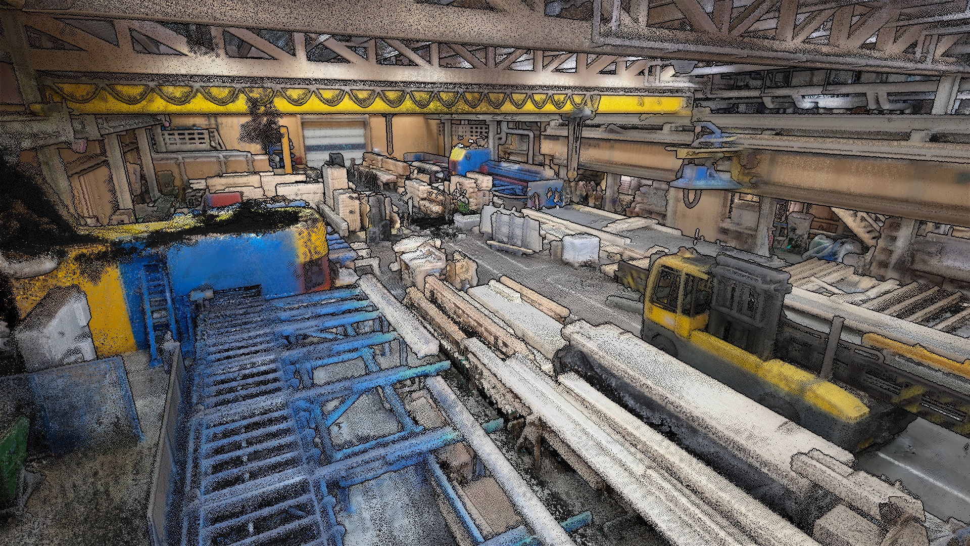
A warehouse captured in full color within minutes using Artec Jet.
3D scanning solves this by capturing the entire facility as it stands today. Walk through with a mobile SLAM scanner, and you produce a complete, dimensionally accurate model of the space. That model becomes the foundation for planning. Engineers can design new layouts, route piping, and check clearances digitally before any physical work begins.
For large plants, scanners can cover different scales. A mobile LiDAR scanner maps the overall building structure and floor layout, while a handheld structured-light scanner captures individual machines and parts at sub-millimeter detail. The end result: fewer surprises during installation, relocation, or modification – as well as a digital record of the facility for future planning.
Geospatial mapping
Surveying and mapping large outdoor areas have traditionally been a slow, labor-intensive process. Conventional methods involve collecting measurements point by point, which produces accurate results but takes time, and the output is typically sparse, so there’s enough data to define key features but not enough to capture full surfaces in detail.
Mobile LiDAR scanning changes the economics of geospatial data collection. A scanner mounted to a backpack, vehicle, or drone captures millions of points per second as the operator moves through the environment, producing a dense 3D point cloud in the process.
For road, railway, and pipeline mapping, a vehicle-mounted scanner captures kilometers of linear assets at driving speed, with RTK positioning providing real-world coordinates accurate to a few centimeters. For site surveys, a backpack or handheld setup covers open ground and transitions seamlessly into buildings or structures where GPS drops out, with SLAM maintaining positional accuracy throughout. Drone-mounted scanning adds an aerial perspective for stockpile volumes, earthworks, and terrain that’s difficult to traverse on foot.
Long story short, you’ve got a solution for tackling all kinds of terrain. Autonomous 3D mapping is perfect for capturing such large environments. Improvements to platforms like Artec Twins are only making it easier to process, visualize, and enhance the accuracy of resulting datasets.
Lesen Sie dies als nächstes
Building Information Modeling (BIM) ist der Branchenstandard für die Planung und Verwaltung von Baustellen und umfasst die Erfassung, Verarbeitung und Speicherung von Informationen über den gesamten Projektlebenszyklus hinweg. Obwohl 3D-Technologien wie LiDAR und Photogrammetrie zunehmend Marktanteile gewinnen, werden sie oft als vom BIM-Ökosystem getrennt betrachtet. In diesem Artikel untersuchen wir, wo diese Lösungen am besten eingesetzt werden und wie sie die Branche voranbringen.
Mehr aus
Dem lernzentrum

Zuweilen haben herkömmliche KMGs Schwierigkeiten, Objekte schnell und nichtinvasiv zu messen, insbesondere wenn die Objekte Löcher oder spröde Oberflächen aufweisen. Glücklicherweise ist das 3D-Scannen technisch mittlerweile so weit, dass derartige Probleme effektiv überwunden werden können. Insgesamt kann 3D-Technologie daher in Inspektions-Anwendungen immer stärker mit KMG-Systemen konkurrieren.
Üblicherweise gelten Koordinatenmessgeräte (KMG) groß, statisch und berührungsbasiert. Optische KMG, wie 3D-Scanner, verändern dieses Bild jedoch, denn sie ermöglichen schnelle, berührungslose 3D-Messungen mit größerer Flexibilität. In unserem Artikel erläutern wir die Unterschiede zwischen den Technologien, erklären ihre Funktionsweise und stellen die neuesten Lösungen für Inspektionen und Prüfungen vor.

Virtual Reality (VR)-Headsets erfreuen sich immer größerer Beliebtheit. Unternehmen wie Apple entwickeln die Technologie in neue Richtungen und eine Vielzahl immer erschwinglicherer Geräte kommen auf den Markt. Mit dem Einzug von VR in den Mainstream stieg auch die Nachfrage nach 3D-Modellen. In diesem Artikel erklären wir, wie Sie Ihre eigenen ultrarealistischen VR-Assets für die virtuelle Welt erstellen können.