Cos'è la fotogrammetria
La fotogrammetria è il processo di acquisizione di misurazioni affidabili partendo da fotografie. Ci ha accompagnato in diverse forme per secoli e ha persino contribuito a plasmare la nostra comprensione della superficie terrestre. Oggi, svolge un ruolo vitale in molti settori. Quindi, ecco un resoconto per darvi un'idea generale di cosa si tratta e di come funziona.
Introduzione
La fotogrammetria è un argomento di ampio respiro. È diventato sempre più popolare nel corso degli anni ed è quindi utilizzata in svariate applicazioni, ognuna con le sue peculiarità. Qui introduciamo i concetti generali che sono alla base della fotogrammetria. Esaminiamo come funziona, alcune sue applicazioni comuni, quale hardware viene tipicamente utilizzato, quando generalmente si utilizza la fotogrammetria e quando no.
Iniziamo con una definizione.
Definizione di fotogrammetria
La fotogrammetria è il processo di acquisizione di misurazioni affidabili partendo da fotografie. Questa definizione potrebbe sembrare un po 'semplicistica, ma l'etimologia del termine lo conferma: "Foto" è greco per la luce, "gramma" significa scrivere o disegnare e "metron" significa misurare.
Potresti anche imbatterti in alcune definizioni di fotogrammetria che includono il prendere misure da schemi di energia radiante elettromagnetica e altri fenomeni. Questo perché in alcuni ambienti la definizione di fotogrammetria include non solo la fotografia, ma anche i dati di altre immagini multispettrali.
PUNTO CHIAVE:
La fotogrammetria è un mezzo per ottenere misurazioni affidabili partendo dalle fotografie.
Ciononostante il principio generale alla base rimane invariato: ottenere informazioni affidabili sulle dimensioni di un oggetto fisico esaminando e interpretando le immagini. Nella maggior parte dei casi queste immagini sono immagini normali provenienti da una fotocamera, di solito una reflex digitale. Questa è la definizione con cui lavoreremo.
Quindi, pensate ad una classica immagine di una scena del crimine con un metro di misura posto accanto a un oggetto di interesse e fotografato. Si può parlare di fotogrammetria in questo caso? Dopotutto, fornisce un mezzo per misurare un oggetto partendo da una fotografia.
Beh, non esattamente. Presto capirete perché.
Come funziona la fotogrammetria?
Definiamo la fotogrammetria come prendere misure affidabili partendo dalle fotografie. La parola "affidabile" non la stiamo usando con leggerezza: in sostanza, l'affidabilità è il cardine della fotogrammetria.
Tornando alla nostra scena del crimine, diciamo che abbiamo una foto di un'impronta sul terreno con un metro forense accanto. Non possiamo determinare con sicurezza la misura della scarpa dall'immagine, anche con il metro a fornire la scala. Se l'impronta si curva su un cumulo di terra, dall'alto, appare più piccola di quanto non sia in realtà.
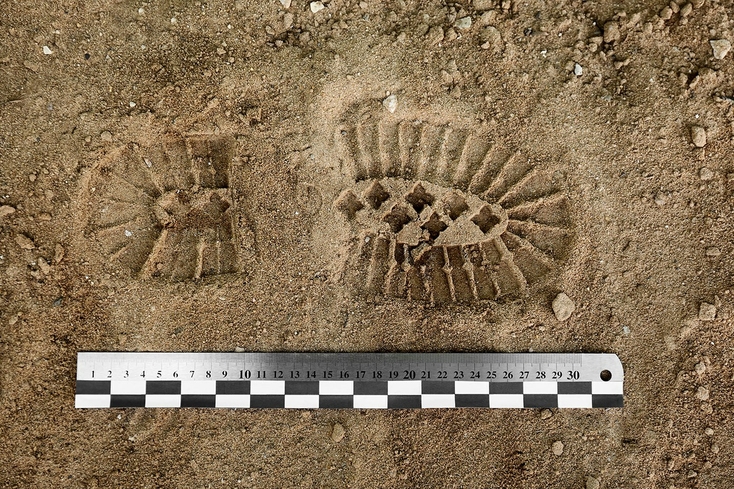
Se questa impronta è stata fatta su un cumulo curvo di terra, potrebbe sembrare più piccola da questa prospettiva, rendendo le misurazioni ottenute da questa immagine inaffidabili.
Per effettuare una misurazione accurata, dobbiamo tenere conto della curvatura della superficie. Ma se la fotocamera è posizionata direttamente sopra l'impronta guardando verso il basso, è cieca ai contorni del terreno.
In che modo la fotogrammetria aggira questo problema?
La risposta breve è l'utilizzo di più immagini sovrapposte da diverse posizioni e angolazioni.
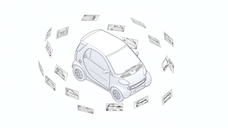
La fotogrammetria deduce le dimensioni da una scena utilizzando più immagini sovrapposte prese da diverse posizioni e angolazioni.
È tutta una questione di prospettiva
La fotogrammetria è incentrata sulla prospettiva e la sua interpretazione. Ciò che la fotogrammetria essenzialmente fa è svolgere il processo fotografico a ritroso. Mentre la fotografia prende un oggetto o una scena e la appiattisce in un'immagine 2D, la fotogrammetria fa il contrario; guarda questa rappresentazione 2D e costruisce un modello 3D partendo dagli indizi nelle immagini.
Ma come lo fa, esattamente?
Sappiamo che le fotocamere vedono gli oggetti in modo simile all'occhio umano. Ad esempio, più un oggetto è vicino alla lente, più grande appare. Pensate ad esempio a una strada rettilinea sembra assottigliarsi in lontananza anche se la sua larghezza non cambia effettivamente.
Una dimostrazione più elaborata di questo concetto appare nel testo di Albrecht Dürer del 1525, Manuale del pittore. Raffigura due uomini che tentano di creare un disegno geometricamente accurato di un liuto. Posizionano il liuto su un tavolo di fronte a una sorta di finestra, ma con una tela al posto del vetro della finestra. Fissano una corda in un punto del muro in cui si troverebbe l'occhio di un osservatore e la fanno passare attraverso la finestra aperta.
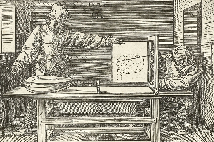
Un'incisione del 1525 tratta dal Manuale del pittore di Albrecht Dürer che dimostra la prospettiva geometrica. La fotogrammetria utilizza questo concetto per dedurre dati 3D da immagini 2D.
Quindi spostano l'estremità opposta della corda attorno a diversi punti del liuto, annotando la posizione della corda nella finestra per ciascuno di questi punti e disegnando un punto sulla tela per ogni posizione della corda nella cornice della finestra. Ciò che emerge è un'immagine geometricamente accurata della matrice di punti del liuto.
La fotogrammetria attinge a questi principi per fare deduzioni sulle dimensioni e le proprietà fisiche degli oggetti. Con un numero sufficiente di immagini sovrapposte che forniscono le informazioni spaziali necessarie, è possibile ricostruire un modello 3D di un intero oggetto o scena.
Triangolazione
Avere immagini sovrapposte è la chiave per la fotogrammetria. Identificando gli stessi punti in più immagini e tenendo conto di parametri come la posizione e l'orientamento della fotocamera per ogni fotografia, la sua lunghezza focale, la distorsione dell'obiettivo e altre variabili, è possibile determinare dove si trovavano tali punti nello spazio 3D. Ciò si chiama triangolazione.

La triangolazione funziona identificando i punti comuni nelle immagini sovrapposte e determinando le loro posizioni nello spazio 3D rispetto alle posizioni note della fotocamera.
Quando un punto viene identificato in almeno due immagini scattate da posizioni note diverse, possiamo tracciare linee immaginarie dalle due posizioni della fotocamera nella direzione di quel punto. Quindi determiniamo matematicamente dove le linee si intersecano. Le linee convergenti ci danno le coordinate XYZ del punto in questione. E con abbastanza punti, possiamo costruire un modello della scena.
Gli esseri umani in realtà fanno la stessa identica cosa intuitivamente. Stiamo essenzialmente camminando con due piccole telecamere nella testa, leggermente distanziate, per aiutarci a percepire profondità e distanza.
Scala e orientamento
Una cosa da notare, tuttavia, è che i modelli fotogrammetrici hanno una proporzione ma non hanno una scala. Per scalare il modello deve esserci almeno una distanza nota.
Questo è simile al modo in cui il nostro cervello ha anche bisogno di un oggetto familiare per aiutarlo a stimare la dimensione di qualcosa che stiamo guardando. Ciò che all'inizio sembra un edificio a grandezza naturale in un'immagine potrebbe rivelarsi un modello in miniatura quando una moneta viene posizionata accanto ad esso. In fotogrammetria, l'equivalente di quella moneta sarebbero le barre di scala.
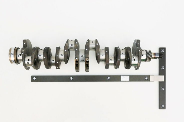
La fotogrammetria fornisce le proporzioni ma non una scala. Senza la barra di scala calibrata a forma di T, è impossibile dire quanto grande (o piccolo) sia questo albero motore.
Le barre di scala sono barre lineari calibrate con indicatori stampati chiamati target. I target sulle barre di scala sono codificati. Ciò significa che il software può identificare in modo univoco ogni target. Target non codificati (come quelli sull'albero motore nella foto) forniscono semplicemente punti di riferimento ad alto contrasto che aiutano a cucire accuratamente le immagini insieme. Non sono identificabili in modo univoco.
I target sulle barre di scala sono separati da una distanza nota e possono quindi essere utilizzati per scalare l'immagine. Per garantire la coerenza e l'accuratezza, le barre graduate sono fabbricate utilizzando materiali le cui dimensioni non varia in modo significativo con i cambiamenti di temperatura.
I target vengono anche posizionati intorno alla scena prima che le immagini vengano scattate per fornire solidi punti di riferimento che verranno abbinati tra le immagini sovrapposte quando le immagini vengono cucite insieme.
Il software di fotogrammetria può riconoscere e abbinare automaticamente i target codificati tra le immagini e utilizzare queste informazioni per allineare le immagini e determinare l'orientamento del modello. I target non codificati vengono inoltre utilizzati per controllare l'accuratezza del modello una volta che il software lo ha elaborato.
La coerenza e la qualità sono fondamentali
Ci sono diversi fattori in gioco che determinano i risultati ottenuti con la fotogrammetria. Hardware come fotocamere, obiettivi e così via determinano la massima qualità che è possibile ottenere. E come ci si aspetterebbe, anche la qualità delle immagini – la risoluzione, la nitidezza, la profondità di campo e altri fattori – sono particolarmente cruciali. Approfondiremo un po' di più questo aspetto più tardi.
Ma a parte la loro qualità, il modo in cui vengono scattate le immagini è altrettanto importante.
L'importante è assicurarsi che l'oggetto venga catturato completamente. Una raccomandazione utile è quella di fare diversi giri completi intorno all'oggetto, scattando sistematicamente foto a distanze diverse in modo che le posizioni della fotocamera creino una sorta di cupola intorno ad esso. Per gli oggetti più piccoli, ci saranno naturalmente meno fotografie. In ogni caso, è meglio sempre assicurarsi che l'intero oggetto sia a fuoco in tutte le immagini per ottenere i migliori risultati.
Per ottenere risultati ottimali, si consiglia di fare diversi giri completi intorno all'oggetto, scattando sistematicamente foto a distanze diverse.
Per oggetti più grandi o scene che non possono essere circondate – la facciata di un edificio, per esempio – la telecamera può essere spostata lungo una linea retta parallela alla facciata dell'edificio. Potrebbero essere necessarie più passaggi per catturare l'intera scena.
PUNTO CHIAVE:
La fotogrammetria svolge il processo fotografico a ritroso. Guardando più immagini e utilizzando principi relativi alla prospettiva geometrica, possiamo produrre un modello 3D da dati 2D.
Nella fotogrammetria aerea, la fotocamera viene montata su un veicolo aereo come un drone, puntando verso il basso. Se si desidera catturare anche i lati di oggetti verticali come edifici o alberi, potrebbe essere una buona idea inclinare la fotocamera un po' al fine di catturare adeguatamente queste superfici. Anche in questo caso, la coerenza è fondamentale.
Tipi di algoritmi fotogrammetrici
Per molti versi, la fotogrammetria funziona come la vista umana. Ciascuno dei nostri occhi registra costantemente immagini sovrapposte che utilizziamo per percepire profondità e distanza. Allo stesso modo, affinché la fotogrammetria funzioni bene, abbiamo bisogno di una serie di foto ben scattate con informazioni sufficienti sulla scena per estrapolare i dati richiesti.
A differenza degli esseri umani, tuttavia, la fotogrammetria non ha il lusso di poter scattare un numero illimitato di foto. La quantità di immagini necessarie per raccogliere le informazioni di cui abbiamo bisogno varierà a seconda delle dimensioni e della complessità dell'oggetto o della scena e, forse ancora più importante, delle esigenze del progetto.
Quindi, mentre i concetti alla base della fotogrammetria rimangono gli stessi, i suoi algoritmi hanno due ampie classificazioni basate sulle esigenze del progetto.
Fotogrammetria per l'ingegneria
Se sei un ingegnere che crea un modello di un oggetto a scopo di controllo qualità, reverse engineering o in qualsiasi altro caso, non hai necessariamente bisogno di ogni singolo pixel nell'immagine. Per disegnare una linea retta, ad esempio, è sufficiente conoscere le posizioni di due punti.
Questo è il concetto alla base di ciò che a volte viene definito come fotogrammetria metrica. Il punto focale di questo ramo della fotogrammetria è la precisione. Lo scopo è quello di ottenere misurazioni e calcoli precisi dalle fotografie determinando, nel modo più accurato possibile, le posizioni relative di alcuni punti rilevanti nelle immagini.

Nella fotogrammetria metrica, l'algoritmo estrae un modello basato su una serie di punti rilevanti. L'obiettivo è la precisione, non catturare ogni singola superficie.
Gli ingegneri quindi posizionano i target, che l'algoritmo riconoscerà, nelle aree di interesse. L'algoritmo utilizza le destinazioni per costruire un modello. Il risultato è una sorta di scheletro dei punti rilevanti, e non una densa nuvola di punti di tutte le superfici.
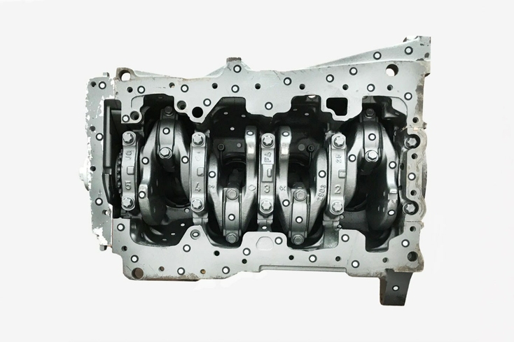
Le destinazioni sono attaccate all'oggetto per facilitare il processo di identificazione e allineamento delle aree sovrapposte tra le immagini.
Questi punti mirati definiscono le dimensioni, la forma e la posizione delle caratteristiche di un oggetto con un'enfasi assoluta sulla precisione. I punti possono essere utilizzati in modo affidabile per calcolare distanze, aree e anche cose come l'elevazione per aiutare a creare una mappa topografica, o volumi e sezioni trasversali per altri usi tecnici.
Fotogrammetria per modellazione 3D a colori
Al contrario, cose come lo sviluppo di giochi, CGI nei film o la conservazione del patrimonio richiedono rendering reali di oggetti del mondo reale. Di regola, più pixel e dettagli puoi inserire nel modello, meglio è. Gli esperti che lavorano in questi settori dispongono del meglio del meglio delle attrezzature fotografiche e saranno quindi già adeguatamente attrezzati anche per la fotogrammetria.
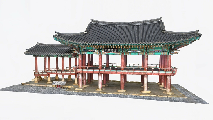
Il compromesso è che la forma finale del modello è solitamente imperfetta. Inoltre, il numero di artefatti e la quantità di rumore con cui si deve avere a che fare durante l'uso della fotogrammetria è di gran lunga maggiore. Il risultato è, in definitiva, un modello con texture ad alta definizione, ma anche molto rumore e una geometria imperfetta. In passato, gli scanner 3D professionali, che catturano molto bene la geometria, a volte avevano difficoltà con superfici lucide, trasparenti o nere, ma questo sta diventando sempre meno un problema e questa tecnologia sta davvero decollando nel campo della CGI.
Con questi tipi di progetti è meglio combinare la fotogrammetria con uno scanner 3D per ottenere risultati ottimali. Esploriamo ulteriormente questo aspetto nella sezione sulla combinazione di scanner 3D e fotogrammetria.
PUNTO CHIAVE:
Ci sono due rami della fotogrammetria: le tecnologie di misurazione tipicamente utilizzate in ingegneria e la visualizzazione a colori finalizzata alla creazione di modelli 3D eccezionalmente realistici, pronti per la CGI, di oggetti del mondo reale.
Hardware per la fotogrammetria
Come abbiamo già coperto parlando di target e barre di scala, le apparecchiature svolgono un ruolo importante nel processo di fotogrammetria.
Questo perché i risultati dipendono interamente dalle immagini utilizzate. Fattori come la risoluzione, l'illuminazione e la profondità di campo svolgono tutti un ruolo cruciale nell'accuratezza e nell'affidabilità delle misurazioni dal modello risultante. Immagini dettagliate e chiare sono di vitale importanza.
Senza addentrarsi troppo nella tana del coniglio delle attrezzature fotografiche, ci sono alcuni concetti utili che meritano di essere discussi. I fotografi, o chiunque conosca la macchina fotografica, sono già un passo avanti. Se termini come lunghezza focale e apertura fanno parte del tuo lavoro o dei tuoi hobby, ci sei già. È possibile saltare le seguenti sezioni e passare alle applicazioni di fotogrammetria.
Sensori
Le fotocamere sono disponibili in tutte le forme e dimensioni, dalle fotocamere dei telefoni cellulari, CCTV, GoPro, alle apparecchiature video professionali a tutti gli effetti. In che misura sono adatti per il tuo progetto potrebbero ridursi alle dimensioni del sensore.
Un sensore è per una telecamera ciò che la retina è per l'occhio umano. Registra l'immagine che passa attraverso l'obiettivo e determinerà quanti dettagli sei effettivamente in grado di catturare. Più grande è il sensore, più punti acquisisci, il che si traduce in un livello di dettaglio più elevato.
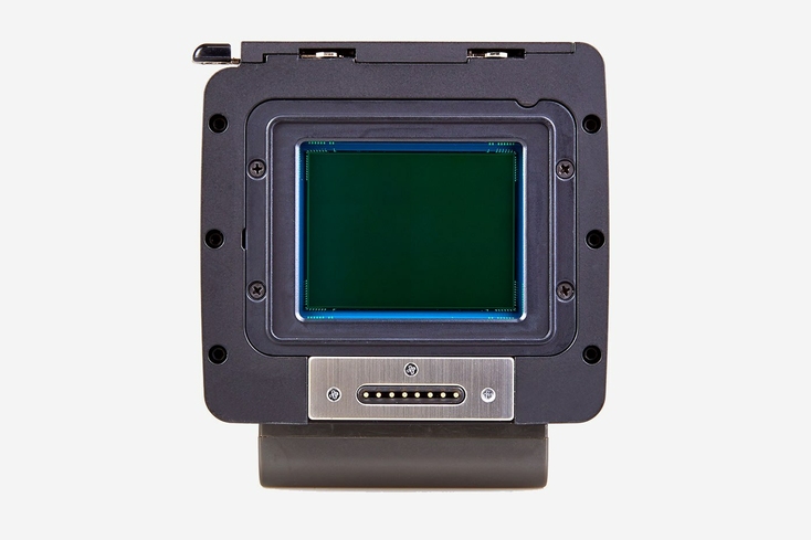
Il sensore all'interno di una fotocamera registra l'immagine che passa attraverso l'obiettivo e determina il numero di pixel delle immagini.
Quindi, mentre una piccola fotocamera point-and-shoot potrebbe svolgere un lavoro passabile nelle giuste condizioni di illuminazione, una reflex digitale di fascia alta con un sensore full-frame (a volte fino a 30 volte la dimensione del point-and-shoot) fornirebbe molti più pixel e quindi una risoluzione molto migliore per il modello 3D.
La dimensione del sensore influenza anche quello che è noto come il fattore di crop. Un obiettivo simile su due sensori diversi catturerà porzioni diverse della scena perché un sensore più piccolo può "vedere" meno, mentre un sensore più grande copre una maggior parte della scena in ogni fotografia.
Obiettivi
Gli obiettivi sono il prossimo pezzo cruciale del puzzle. Si tratta di ciò che piega la luce e la focalizza sul sensore della fotocamera. Determina cosa è a fuoco, l'esposizione, l'ingrandimento e quanto è ampio o stretto l'angolo di visione nell'immagine.
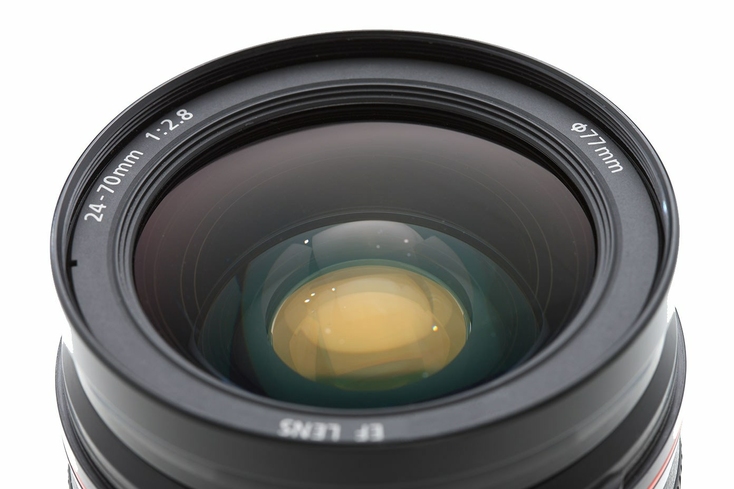
L'obiettivo è ciò che piega la luce e la focalizza sul sensore della fotocamera. Ha un effetto diretto sulla qualità delle immagini.
L'obiettivo ha un pezzo di vetro curvo a un'estremità e la sua apertura (il foro ridimensionabile attraverso il quale la luce fluisce nella fotocamera) all'altra. L'immagine viene catturata quando l'otturatore della fotocamera si apre e si chiude, consentendo brevemente alla luce sul sensore di attraversare l'apertura dell'obiettivo. Tutti questi pezzi si combinano per determinare le caratteristiche dell'immagine e sono quindi importanti considerazioni in fotogrammetria.
Lunghezza focale
La lunghezza focale si riferisce alla distanza ottica in millimetri tra il sensore della fotocamera e il punto dell'obiettivo in cui convergono i raggi luminosi. La lunghezza focale determina l'angolo di visione e l'ingrandimento. Un numero minore (una lunghezza focale più corta) significa un campo visivo più ampio e un ingrandimento inferiore, in modo che la fotocamera possa catturare più scene. In fotogrammetria, di solito si avrà una lunghezza focale fissa.
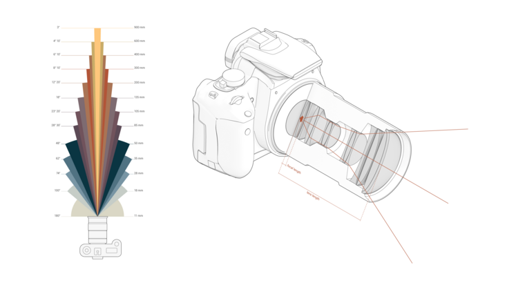
La lunghezza focale dell'obiettivo determina l'ingrandimento e il campo visivo, ovvero quanta parte della scena può essere catturata.
Apertura
Questo è un numero, espresso in f-stop, che descrive l'ampiezza dell'apertura del diaframma dell'obiettivo per far entrare la luce nella fotocamera. Ogni f-stop raddoppia la quantità di luce che entra nella fotocamera. Per quanto possa confondere, un numero grande, come f-32, significa una piccola apertura, e un numero piccolo significa un'apertura più ampia.
L'apertura determina direttamente la profondità di campo, ossia quanta parte della scena è a fuoco. Un'ampia apertura manterrà un sottile strato dell'immagine a fuoco e sfocherà il resto. Questo porterebbe a buoni risultati nella fotografia di ritratto, per esempio, per ottenere una nitida messa a fuoco sul soggetto, e un ricco effetto sfocato sullo sfondo. Questo tipo di sfocatura è nota come sfocatura di messa a fuoco.
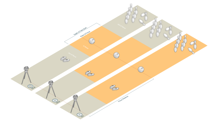
L'apertura determina la profondità di campo, ossia quanta parte della scena è a fuoco.
Per la fotogrammetria, si vuole tenere a fuoco il più possibile la scena. Le immagini sfocate rendono più difficile unire le immagini.
Possiamo ora passare all'altro tipo di sfocatura, il mosso, ossia la sfocatura causata da movimento.
Velocità dell'otturatore e mosso
La velocità dell'otturatore indica per quanto tempo l'otturatore della fotocamera rimane aperto e consente alla luce di cadere sul sensore. Di solito è espresso in frazioni di secondo. Oltre a influenzare la quantità di luce che cade sul sensore, la velocità dell'otturatore si riferisce anche direttamente alla sfocatura del mosso.
Se il soggetto, o la fotocamera, si muove mentre l'otturatore è aperto, l'immagine risultante risulterà sfocata. Un buon esempio di questo effetto è il modo in cui un'immagine di un elicottero in volo ad una velocità dell'otturatore sufficientemente elevata congela le pale del rotore in movimento, mentre una velocità dell'otturatore più lenta sfoca il movimento in modo che le pale non siano visibili.
Se si stanno scattando foto a mano, si consiglia di utilizzare una velocità di scatto sufficientemente elevata per contrastare i leggeri movimenti delle mani mentre si tiene la fotocamera. In alternativa, è possibile utilizzare un treppiede per garantire che la fotocamera rimanga completamente ferma.

La velocità dell'otturatore determina la sfocatura del mosso. Una maggiore velocità dell'otturatore blocca l'azione mentre una più lenta la sfoca.
Alla fine, tutti questi fattori devono essere attentamente considerati per garantire che si ottengano i migliori risultati possibili con la fotogrammetria.
PUNTO CHIAVE:
Poiché la fotogrammetria si basa sulla qualità delle immagini utilizzate nel processo, è fondamentale per ottenere i giusti concetti di fotografia. La risoluzione dell'immagine, le diverse proprietà dell'obiettivo e le impostazioni della fotocamera come la lunghezza focale, la velocità dell'otturatore e altre ancora svolgono un ruolo fondamentale.
Software di fotogrammetria
C'è una grande varietà di software di fotogrammetria sul mercato. Con una piccola ricerca, puoi trovare qualsiasi cosa, dalle applicazioni gratuite, ai pacchetti software che costano migliaia di dollari. Ancora una volta, tutto dipende da quali sono le tue esigenze e quali risorse sono a tua disposizione.
Se stai appena iniziando con la fotogrammetria, potrebbe essere una buona idea iniziare con soluzioni gratuite come 3DF Zephyr, Meshroom o Visual SFM. Tuttavia, queste offrono funzionalità limitate e possono essere più lente o produrre risultati meno accurati. Potrebbe anche essere necessario installare plug-in aggiuntivi per essere in grado di fare cose come creare mesh testurizzate con il colore.
Se hai bisogno di più funzionalità, puoi optare per opzioni più complete come Elcovision, iWitness o Photomodeler. MetaShape, Pix4D e Reality Capture sono anche opzioni popolari.
Per i professionisti che utilizzano la fotogrammetria per la metrologia, un pacchetto come Aicon 3D Studio di Hexagon fornisce strumenti intelligenti e potenti per il controllo, il monitoraggio e l'analisi della produzione.
Per i professionisti CGI o chiunque desideri il meglio in assoluto in termini di geometria e qualità della texture, Artec Studio offre un flusso di lavoro semplice che consente di ottenere una geometria perfetta e un'eccellente qualità della texture. Il software ha ricevuto un aggiornamento che rende la mappatura della texture su dati mesh ottenuti con uno scanner 3D fluida e senza interruzioni.
I pluripremiati scanner 3D di Artec sono in grado di eseguire scansioni estremamente accurate, raggiungendo parametri di riferimento leader del settore come una precisione fino a 0,05 mm per Artec Space Spider, uno dei modelli portatili, e una precisione ancora più elevata fino a micron con Artec Micro II, uno scanner desktop.
Grazie alle potentifunzionalità di Artec Studio, puoi allineare automaticamente le foto ad altissima risoluzione di una fotocamera con le scansioni 3D di scanner di precisione metrologica e ottenere modelli 3D incredibilmente realistici.
Applicazioni della fotogrammetria
La fotogrammetria come tecnica è popolare non solo per la sua versatilità e costo, ma anche per la sua efficacia su lunghe distanze. Diamo un'occhiata ad alcuni dei suoi usi più comuni.
Grandi progetti di ingegneria
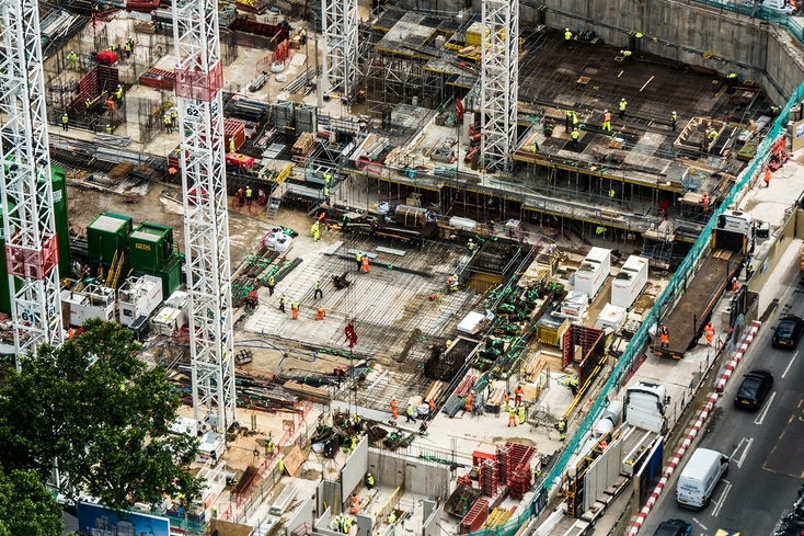
La fotogrammetria aerea è comunemente utilizzata dagli ingegneri nei grandi progetti di costruzione.
Data la sua accuratezza durante la scansione su grandi distanze, la fotogrammetria viene utilizzata dagli ingegneri insieme a droni o aerei per pianificare e valutare grandi progetti di costruzione. Ad esempio, la posizione e la progettazione delle autostrade. I dati della fotogrammetria metrica potrebbero essere utilizzati per calcolare la grandezza di un terrapieno e per fornire note essenziali sul terreno per gli ingegneri civili. È anche essenziale quando si valuta lo stato di avanzamento dei progetti, in quanto fornisce rendering 3D fase per fase nel tempo.
Film e intrattenimento
Con l'aiuto della fotogrammetria, l'industria videoludica e quella del cinema sono state in grado di migliorare la loro capacità di creare ambienti dall'aspetto realistico. Combinando la fotogrammetria e gli scanner 3D, i registi possono creare progetti di set partendo da modelli di scansione 3D accurati sovrapposti alle informazioni sui colori della fotogrammetria. I progettisti di giochi sono anche in grado di creare risorse credibili e di alta qualità e ambienti realistici.
Prendiamo ad esempio il moderno sparatutto in prima persona dello sviluppatore di videogiochi The Farm 51: World War 3. Con gli scanner 3D portatili a luce strutturata, lo studio è stato in grado di digitalizzare rapidamente qualsiasi oggetto di gioco, dalle borse alle persone, e trasformare i dati acquisiti in modelli di personaggi ultra realistici.
Scienza forense
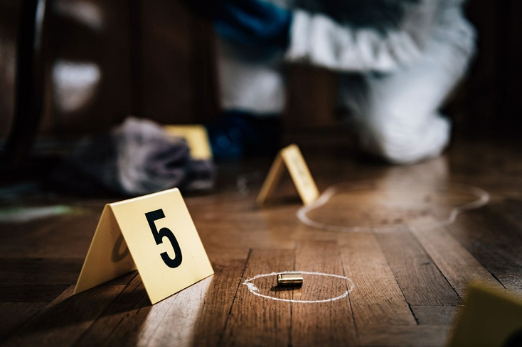
La fotogrammetria gioca un ruolo cruciale nelle indagini sulla scena del crimine.
La fotogrammetria metrica ha anche svolto un ruolo importante nelle indagini sulla scena del crimine. In molti casi, sono i piccoli dettagli a fare la differenza. Essere in grado di catturare con precisione una scena di un crimine o di un incidente con misurazioni precise può essere fondamentale non solo nei casi giudiziari, ma forse ancora più importante, nel rendere queste aree più sicure.
Un esempio è come, analizzando i segni di pneumatici in un'immagine di un manto stradale, gli investigatori sono stati in grado di determinare se i segni di slittamento corrispondessero alle dimensioni di un'auto che una donna stava guidando e alla sua posizione sulla strada rispetto a un secondo veicolo che ha colpito la sua auto e l'ha ferita gravemente. La fotogrammetria metrica si è dimostrata fondamentale per risolvere i resoconti contrastanti delle posizioni dei due veicoli quando si è verificato l'incidente.
Anche queste applicazioni non sono appannaggio esclusivo della fotogrammetria. Anche la scansione 3D per la medicina legale è una tendenza emergente che continua a prendere slancio. Che si tratti di digitalizzazione della scena del crimine o di ricostruzione di incidenti stradali, la scansione 3D ad alta velocità e accurata di livello professionale sta già aiutando gli investigatori a raccogliere prove di casi giudiziari.
Agrimensura
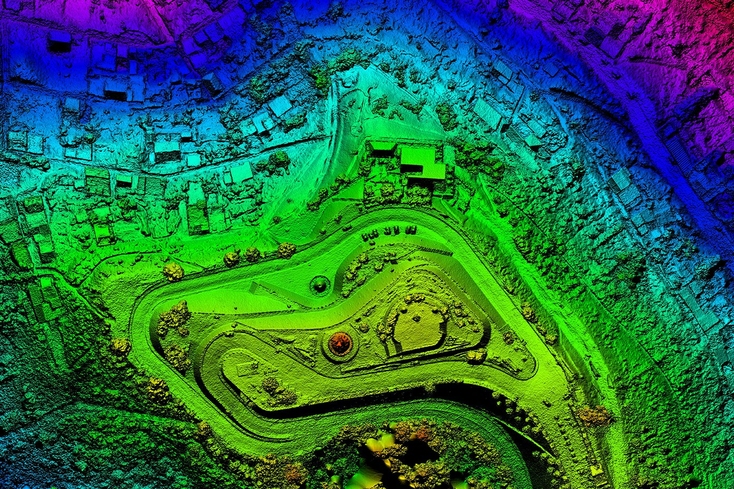
La fotogrammetria aerea è spesso utilizzata dai comuni e dagli ingegneri civili per rilevamenti di agrimensura.
La fotogrammetria metrica è utilizzata anche da squadre di costruzione, architetti e comuni per determinare i confini della proprietà, per pianificare progetti di costruzione o per l'analisi dei dati. Anche le immagini satellitari forniscono queste informazioni, ma la fotogrammetria aerea spesso offre una migliore precisione per aree specifiche di interesse.
Operando su scala di edificio, molti ingegneri e architetti utilizzano anche la scansione LiDAR per acquisire modelli dettagliati del sito e aumentare l'efficienza. Nelle fabbriche, aziende del calibro di Dodman Ltd. stanno persino creando gemelli digitali per la pianificazione e la revisione. Nel suo caso, l'azienda ha scoperto che la combinazione di LiDAR con la scansione 3D portatile è la soluzione di digitalizzazione definitiva, capace di catturare un'intera fabbrica in alta risoluzione in meno di un giorno.
Fotogrammetria nel settore immobiliare
La fotogrammetria viene utilizzata anche per creare modelli virtuali di case che possono essere visualizzati dai potenziali proprietari. Molti acquirenti si affidavano già alle inserzioni online per prendere decisioni di acquisto. Dopo il Covid-19, questo spostamento verso la visualizzazione online si è fatto sempre più presente. A una frazione del costo, la moderna fotogrammetria consente alle agenzie immobiliari di creare un'esperienza virtuale delle case che pubblicizzano.
Mapping
Insieme alla fotografia di droni, aerei o satelliti, la fotogrammetria viene utilizzata per mappare i terreni in 3D. Utilizzando immagini ad alta risoluzione prese da aeromobili o veicoli sommergibili, è possibile creare modelli di aree difficili da raggiungere – anche sott' acqua – con tempi di consegna molto più rapidi.
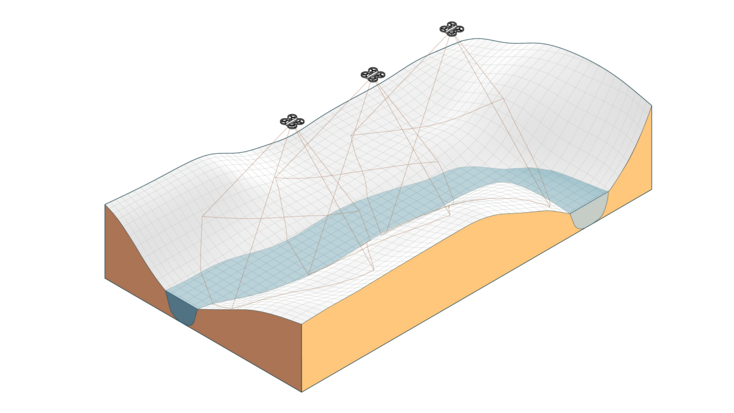
Le foto scattate da droni, aerei o satelliti sono state utilizzate per mappare i terreni in 3D
Google Earth è ad oggi il progetto più ambizioso che ha utilizzato la fotogrammetria per creare immagini accurate del terreno del nostro pianeta. Google utilizza miliardi di immagini provenienti da più fonti – Street View, antenne e immagini satellitari – tutte cucite insieme per mostrare i dettagli di un'area, comprese le distanze precise tra gli oggetti come strade, segnali stradali, edifici e fiumi.
Archeologia
In archeologia, la capacità di mappare un'area e comprendere il layout e la struttura di un sito è assolutamente essenziale. La fotogrammetria metrica offre agli archeologi la possibilità di mappare un'area e registrare i manufatti di interesse in modo rapido e accurato. La possibilità di condividere i rendering 3D facilita anche la collaborazione con altri archeologi che potrebbero non essere presenti in loco.
Lo stesso si può dire per la scansione 3D archeologica. Lavorando con Time Team, Shadow Tor Studios ha persino iniziato a utilizzare la tecnologia per catturare i reperti in tempo reale. Sebbene questo sia stato più un caso di studio nella digitalizzazione che nella misurazione, il realismo e la velocità con cui i dati sono stati acquisiti e modellati in 3D sono ancora piuttosto impressionanti!
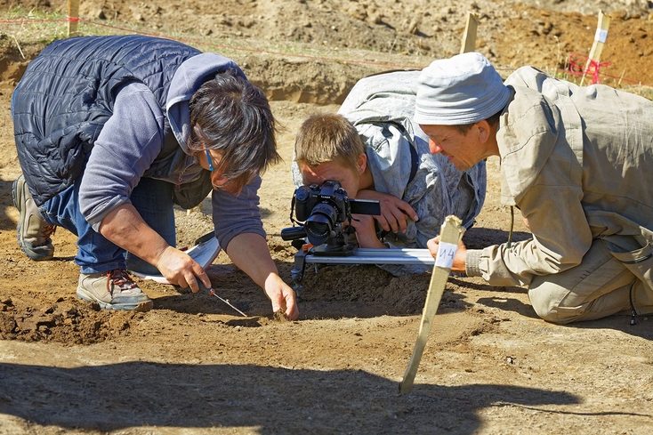
Uno degli usi più comuni della fotogrammetria è nella conservazione del patrimonio culturale.
PUNTO CHIAVE:
La fotogrammetria è utilizzata in un'ampia varietà di scenari in molti settori diversi. Viene in gran parte applicata in situazioni che sono legate alla misurazione, o per modellare oggetti della vita reale.
Quando non utilizzare la fotogrammetria
Ci sono alcune insidie da tenere a mente quando si decide se optare per la fotogrammetria o meno. In poche parole, gli elementi da tenere in considerazione si basano sulle esigenze del progetto.
Fotogrammetria metrica senza attrezzatura specializzata
Se il tuo obiettivo è effettuare misurazioni accurate e le informazioni sui colori non sono una priorità, dovresti utilizzare la fotogrammetria solo se disponi di un buon kit di fotogrammetria specificamente progettato per le applicazioni relative alle misurazioni, come i sistemi di fotogrammetria di fascia alta di Hexagon. Questi vengono forniti con una fotocamera digitale, una serie di target e una serie di barre di scala accuratamente calibrate per garantire che tu sia completamente equipaggiato per il tuo compito.
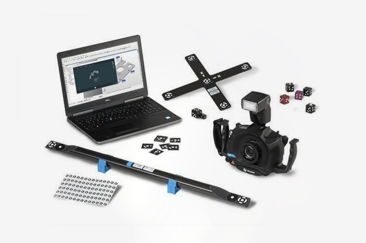
Kit fotogrammetrico completo appositamente progettato per applicazioni legate alla misurazione.
Tuttavia, tieni presente che anche un kit di tale precisione, rispetto a un buon scanner 3D, produrrà solo una nuvola di punti sparsa.
Se hai bisogno di misurare con precisione assoluta, puoi anche investire in un sistema di misurazione ottica 3D dedicato, come Artec Metrology Kit. Quando si tratta di ispezione industriale, questo particolare kit è l'ideale, offrendo sia un'elevata precisione a distanza come soluzione di misurazione indipendente sia uno strumento di riferimento più che capace.
Alta precisione con una nuvola di punti densa
Quindi, se hai bisogno di una nuvola di punti densa e di precisione, uno scanner come Artec Eva, che è in grado di catturare ed elaborare contemporaneamente fino a due milioni di punti al secondo, con una precisione fino a 0,1 mm, è una scelta di gran lunga migliore.
Infatti, con la sua tecnologia di scansione a luce strutturata, Eva cattura con precisione oggetti di quasi tutti i tipi, compresi oggetti con superfici nere e lucide, senza bisogno di target, rendendola un'ottima soluzione a tutto tondo.
Svantaggi generali della fotogrammetria
Nel complesso, la fotogrammetria comporta alcuni svantaggi. Richiede tempo, richiede una buona quantità di esperienza per essere eseguita correttamente e, anche in questo caso, potrebbe non produrre i risultati di cui hai bisogno se le condizioni non sono ideali. Potrebbe essere necessario scattare decine – a volte centinaia – di foto una per una, assicurandosi che ogni immagine sia di qualità sufficientemente elevata e che vi sia un'adeguata sovrapposizione tra le immagini.
Inoltre, a meno che non ti sia preso la briga di preparare la scena con un'illuminazione controllata, dovrai anche assicurarti che non ci siano cambiamenti drammatici nelle condizioni di illuminazione da una foto all'altra. Un'ombreggiatura che ricade sull'oggetto in un'immagine, ad esempio, verrà visualizzata anche nel modello finale.
La fotogrammetria richiede un'illuminazione uniforme e adeguata, quindi è necessario pianificare e preparare la scena di conseguenza.
Al contrario, la maggior parte degli scanner 3D portatili produce la propria luce e illuminerà il soggetto durante la scansione. Quindi, a meno che il tuo obiettivo non sia ottenere una texture della migliore qualità possibile dalla tua scansione, non dovrai preoccuparti della luce quanto dovresti con la fotogrammetria. Con gli scanner 3D portatili, è necessaria relativamente poca preparazione per scansionare una scena.
PUNTO CHIAVE:
è generalmente meglio utilizzare uno scanner 3D quando si desidera una nuvola di punti densa e altamente accurata. La fotogrammetria funziona bene quando si desidera una texture realistica e si dispone di un'ottima fotocamera, meglio di quella di uno scanner 3D. È meglio utilizzare la fotogrammetria a scopo di misurazione solo se si dispone di un kit professionale e si è felici di ottenere una nuvola di punti sparsi.
Lo scanner wireless Artec Leo è dotato di un touch screen che offre feedback in tempo reale, in modo da ottenere un'esperienza di scansione completamente mobile e intuitiva. Con elaborazione interna, una batteria integrata e un livello di connettività wireless che consente di eseguire lo streaming su un secondo dispositivo, Leo consente agli utenti di eseguire la scansione come se stessero girando un video: punta, fai clic e via.
D'altra parte, la fotogrammetria ha i suoi vantaggi. Può essere fatta ad un costo inferiore rispetto alla scansione 3D. Inoltre, funziona bene se si esegue la scansione di una grande area, in genere più di pochi metri.
Combinare la fotogrammetria con la scansione 3D
Per farla breve: se la texture è di importanza secondaria ed è più importante produrre nuvole di punti densi con rumore minimo e precisione molto elevata, la scansione 3D è la strada da percorrere. I migliori scanner 3D offrono capacità di scansione estremamente rapide, elaborazione automatica e una precisione del punto 3D fino alle frazioni di millimetro.
Tuttavia, se il tuo progetto richiede modelli realistici e texture realistiche e non per forza un'attrezzatura fotografica top di gamma, potresti considerare la fotogrammetria. L'avvertenza è che con la fotogrammetria per la texture, bisogna accontentarsi di una geometria imperfetta. Questo perché se vuoi una texture, hai bisogno di più foto, che vanno scattate senza target. Quindi si otterrà una grande quantità di rumore e artefatti, e si perderà invariabilmente precisione.
Puoi ancora attingere al meglio di entrambe le soluzioni combinando la fotogrammetria con i dati di scansione 3D, una tecnica dimostrata nel video qui sotto in cui la fotogrammetria è stata utilizzata con Artec Eva per produrre questo modello mozzafiato di auto.
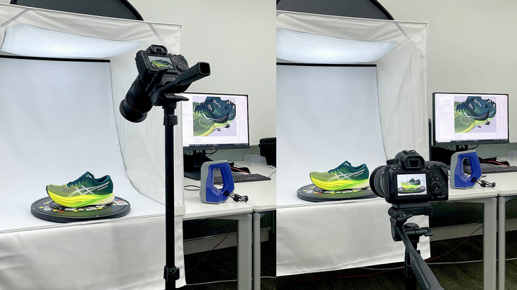
Oppure osserva questa splendida scarpa da corsa catturata usando uno scanner portatile Artec Space Spider, per esempio. Il modello finale è stato cucito insieme da oltre 300 immagini e combinato con i dati scansionati. Il colore è brillante, e il livello di dettaglio semplicemente eccezionale.
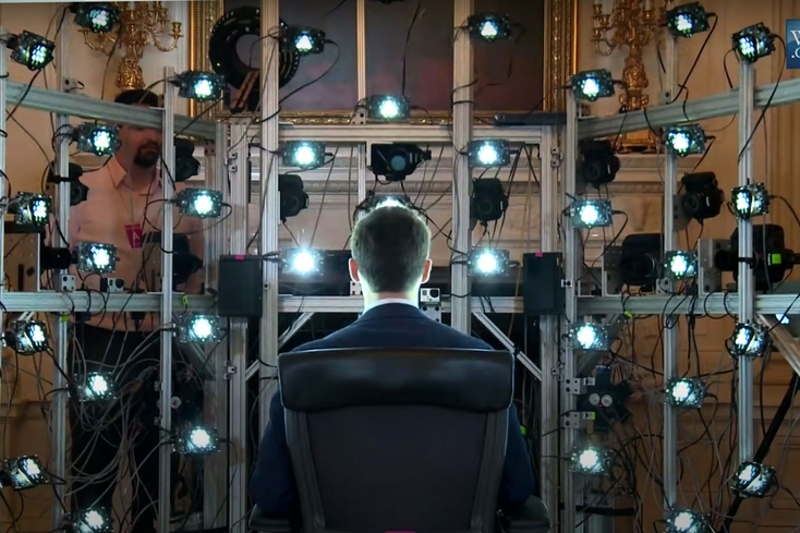
La combinazione dei due è la soluzione ottimale e quella preferita anche dai professionisti del settore più esigenti. Ad esempio, le immagini di una serie di fotocamere posizionate intorno al presidente Barack Obama sono state combinate con i dati scansionati da Artec Eva per creare il primo ritratto 3D di un presidente degli Stati Uniti.
Le fotocamere hanno fornito una texture ricca e dettagliata, mentre l'accuratezza dello scanner 3D ha prodotto una struttura con un rumore minimo attorno alla quale applicare la texture.
Leggi anche questo
Altre informazioni da
Il centro di apprendimento
Negli ultimi tempi, le barriere che un tempo rendevano la fotogrammetria inaccessibile al vasto pubblico, principalmente il prezzo e il tipo di tecnologia, stanno andando a scomparire. Ciò ha permesso un'adozione più diffusa, incentivando lo sviluppo di software migliori, con più funzionalità e con una maggiore facilità di utilizzo. Andiamo a scoprire le migliori soluzioni disponibili. Affronteremo i seguenti temi: compatibilità, prezzi, vantaggi e svantaggi e altri dettagli importanti per aiutarti a sondare il terreno se sei alla ricerca di una soluzione per le tue esigenze di fotogrammetria.
Nell'ultimo decennio, i modelli e gli ambienti dei personaggi in CGI e nei videogiochi hanno fatto passi da gigante, non solo a causa degli aggiornamenti hardware, ma anche per l'adozione di tecnologie di digitalizzazione come la fotogrammetria, capace di trasformare foto e video in bellissimi modelli 3D. Nel seguente articolo portiamo questo argomento sotto i riflettori, spiegando ogni dettaglio, dai passaggi del flusso di lavoro alla prospettiva di utilizzare la scansione 3D come alternativa.
Dopo aver esaminato i principali elenchi di scanner 3D disponibili su Internet, abbiamo notato che la maggior parte di essi non include informazioni sui parametri chiave degli oggetti da scansionare. Elementi importanti come le dimensioni degli oggetti e le applicazioni per le quali utilizzerai lo scanner non sono adeguatamente affrontate. Questa panoramica ha lo scopo di colmare questa lacuna e aiutarti a trovare la migliore soluzione 3D per il tuo progetto.


